Lake Murray
The largest lake in Papua New Guinea, a shallow flooded forest system in the remote Western Province.
Updated 21 October 2026
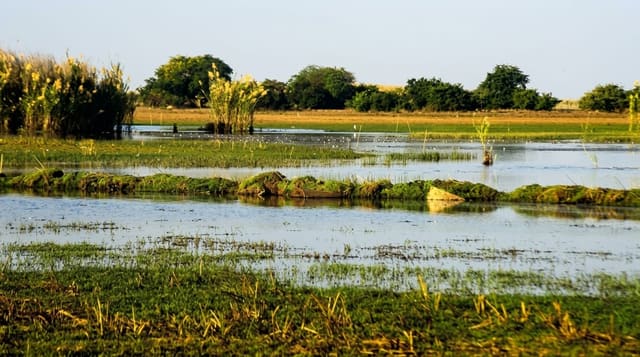
Lake Murray lies in the interior of Western Province, the largest lake in the country, a shallow body whose area changes enormously between seasons as the Strickland and Herbert rivers flood into it, spreading over drowned forest so that dead trees stand out of the water across large stretches. It holds barramundi, saratoga and other fish worked by the villages, along with crocodiles in numbers. Around it the forest is lowland rainforest with a rich bird list including birds-of-paradise. There are no roads: access is by light aircraft to the airstrip, and movement on the lake is by boat. Villages live on the shore and on stilts over the water, and infrastructure is essentially absent.
History
Some 4,000 Boazi- and Zimakani-speaking people have long lived around the lake, building their villages on the sand ridges and islands above the swamps. A government patrol reached it in August 1913 and named it after the Lieutenant-Governor, Sir Hubert Murray, who visited the next year; a mission settled at Pangoa on the lake in 1947, and a permanent government station was laid out in 1960 (Wikipedia, Lake Murray (Papua New Guinea)).
What you'll find
- The drowned forest - the dead trees standing out of the shallow water.
- The changing shoreline - the lake expanding and contracting with the seasons.
- Crocodiles and fish - the barramundi fishery and the crocodile population.
- Shore villages - the settlements on the water and its edges.
When to go
May to October in the drier season, when water levels are lower and flying more reliable; the wet season floods the lake to its greatest extent. Flights are chartered or on limited scheduled services.
Good to know
Access is by light aircraft only and flights are few and unreliable. There is no accommodation beyond village arrangements and one small lodge. Crocodiles make swimming inadvisable. Supplies and communications are minimal.
Nearby
Kiunga lies north on the Fly river; the Strickland runs into the lake.
Key facts
Source: Wikidata, item Q1635229, read on 18 October 2026.
What to pack for Lake Murray
Chosen from what this place is for. Tap a kit for the full checklist.
- Reef-safe sunscreen - High SPF that will not bleach the coral you are swimming over. Find on Amazon
- Strong insect repellent - DEET or picaridin; the jungle is where bites and disease risk are highest. Find on Amazon
- Quick-dry towel - A microfibre towel packs small and dries in minutes. Find on Amazon
- Long, light, quick-dry clothing - Covers skin from insects and sun without cooking you in the humidity. Find on Amazon
Some links on this page are Amazon affiliate links - if you buy through them we may earn a small commission at no extra cost to you.
All packing kitsPlan your trip
Where to start if Lake Murray is going on the list.
Booking links on this page are affiliate links - if you book through them we may earn a small commission at no extra cost to you. It never changes what we write about a place.
Opening times, ticket prices and seasonal closures change - check the official source before you go: official site.