Lake Pukaki
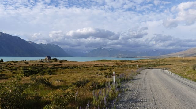
A glacial lake whose extraordinary blue comes from suspended rock flour, aimed straight at Aoraki.
Updated 21 October 2026
Pukaki is fed by the Tasman and Hooker glaciers through the Tasman River, and the meltwater carries an enormous load of rock flour - rock ground to particles fine enough to stay suspended indefinitely. Those particles scatter light in a way that produces the lake's particular opaque milky blue, quite different from the clear blue of a mountain lake, and it changes with the season and the light. The lake was raised twice for hydroelectricity, by nine metres in 1952 and by thirty-seven metres in 1976, so the current shoreline is not the natural one. What makes it more than another pretty lake is the alignment: from the southern end the valley points directly at Aoraki, so on a clear day the mountain sits at the head of the water. The main lookout on SH8 is where every tour bus stops; quieter pull-offs run up the eastern shore road toward Mount Cook Village.
Highlights
- The rock-flour blue - opaque and milky, not clear water.
- Aoraki at the head - the valley aimed straight at the mountain.
- The lookouts - the main SH8 stop and quieter ones up the east shore.
- The raised shoreline - the result of two hydro schemes.
When to go
Any season - winter gives the sharpest air and snow on the peaks. The mountain is often in cloud, so a clear day matters more than the month. Early or late light is best.
What to expect
Aoraki is hidden by cloud on a large share of days. The main lookout is crowded with coaches through the middle of the day. The water is glacial and swimming is genuinely dangerous cold. Wind is constant.
Nearby
Mount Cook Village and the Hooker Valley are north; Tekapo and Twizel are on the highway.
Key facts
Source: Wikidata, item Q1347588, read on 18 October 2026.
What to pack for Lake Pukaki
Chosen from what this place is for. Tap a kit for the full checklist.
- Reef-safe sunscreen - High SPF that will not bleach the coral you are swimming over. Find on Amazon
- Warm base layers - Merino or synthetic against the skin - never cotton, which chills when damp. Find on Amazon
- Quick-dry towel - A microfibre towel packs small and dries in minutes. Find on Amazon
- An insulated + windproof jacket - A down or synthetic layer under a hard shell handles most cold. Find on Amazon
Some links on this page are Amazon affiliate links - if you buy through them we may earn a small commission at no extra cost to you.
All packing kitsPlan your trip
Where to start if Lake Pukaki is going on the list.
Booking links on this page are affiliate links - if you book through them we may earn a small commission at no extra cost to you. It never changes what we write about a place.
Opening times, ticket prices and seasonal closures change - check the official source before you go: official site.