Wicklow Mountains National Park
Twenty thousand hectares of granite dome, blanket bog and glacial valley within an hour of Dublin.
Updated 28 August 2026
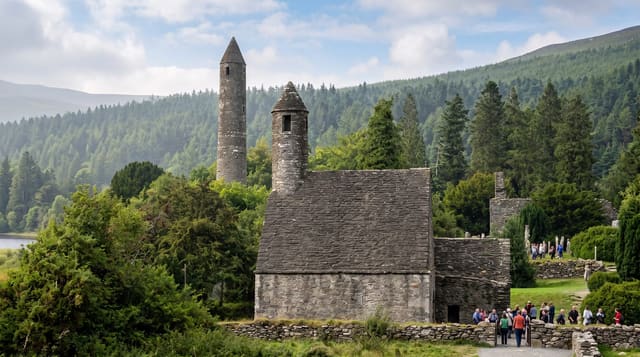
The Wicklow Mountains are a single mass of granite pushed up around four hundred million years ago and then carved by ice into rounded summits and steep-sided valleys. The national park covers about twenty thousand hectares of it, most of that blanket bog and upland heath, with Lugnaquilla at 925 metres the highest ground in Leinster. The peat here is deep and holds an enormous volume of carbon and water; walking off the marked routes in it is far harder and wetter than the map suggests. The Military Road, built after the 1798 rebellion to give troops access to the mountains, still runs the spine of the park and is the standard drive. The park visitor centre is at Glendalough, which absorbs most of the visitors and leaves large areas of the uplands empty. Weather changes quickly and the tops carry cloud far more often than the valleys.
Highlights
- The blanket bog - deep peat over most of the upland, and hard walking.
- The Military Road - the 1800s route that still crosses the park.
- Lugnaquilla - 925 metres, the highest ground in Leinster.
- The glacial valleys - Glendalough, Glenmalure and Glenmacnass.
When to go
May to September for the longest days and the driest ground. Heather colours the slopes in August. Cloud sits on the tops in any month; check the forecast before going high.
Before you go
Bog off the marked paths is genuinely difficult and often waist-deep in wet places. Phone coverage is patchy in the valleys. Glendalough car parks fill by mid-morning at weekends. Weather on the tops can be twenty degrees colder than Dublin.
Nearby
Glendalough is at the park's centre; Lough Tay and the Sally Gap are on the Military Road.
Key facts
Source: Wikidata, item Q3364505, read on 18 October 2026.
What to pack for Wicklow Mountains National Park
Chosen from what this place is for. Tap a kit for the full checklist.
- Broken-in walking shoes or boots - Grip and ankle support matter more than looks; never hike in brand-new boots. Find on Amazon
- Binoculars - The single best wildlife tool - even a compact pair transforms a sighting. Find on Amazon
- Layers + a waterproof shell - Mountain weather turns fast; a packable rain jacket saves the day. Find on Amazon
- A zoom camera or long lens - Animals rarely come close; reach beats megapixels. Find on Amazon
Some links on this page are Amazon affiliate links - if you buy through them we may earn a small commission at no extra cost to you.
All packing kitsPlan your trip
Where to start if Wicklow Mountains National Park is going on the list.
Booking links on this page are affiliate links - if you book through them we may earn a small commission at no extra cost to you. It never changes what we write about a place.
Opening times, ticket prices and seasonal closures change - check the official source before you go: official site.