Uaxactun
A Maya site north of Tikal whose plaza gave archaeology the name for an astronomical building group.
Updated 19 October 2026
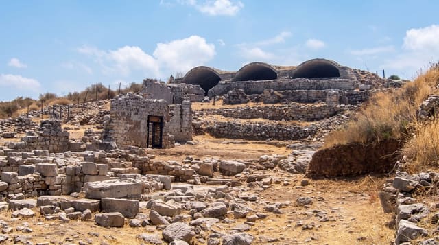
Uaxactun lies a short distance north of Tikal and is small by comparison, but it matters out of proportion to its size. Its Group E consists of a pyramid on the west side of a plaza facing a long platform on the east carrying three small structures, positioned so that from the pyramid the sun rises over the outer buildings at the solstices and the centre one at the equinoxes; when this was recognised in the 1920s it gave archaeologists the template, and every arrangement of the kind found since is called an E-Group. Structure E-VII-sub, an early pyramid preserved beneath a later one, keeps its stucco masks.
History
The archaeologist Sylvanus Morley rediscovered the site in May 1916 and named it Uaxactun, "eight stones", after an inscription from the 8th Baktun of the Maya calendar, corresponding to 328 AD and then the earliest known Maya date. Frans Blom mapped it in 1924, and the Carnegie Institution excavated it from 1926 to 1937 under Oliver Ricketson, work that led to the naming of the "E-Group", since Group E here became the model for Maya astronomical complexes across the lowlands; a small village grew up around the airstrip as a centre for gathering chicle (Wikipedia, Uaxactun).
What to look for
- The original E-Group - the plaza that named a whole class of buildings.
- Structure E-VII-sub - an early pyramid with stucco masks preserved.
- Solstice and equinox alignments - the arrangement the group was built for.
- A quiet site near a busy one - far fewer visitors than Tikal.
When to go
January to April, the dry season, when the road north from Tikal is passable. A day. Trips are usually arranged from Flores or at Tikal.
Things to know
The road from Tikal is rough and impassable after heavy rain. The site is small and low, and much of it is unrestored. There are few facilities. Most visitors combine it with Tikal rather than travelling for it alone.
Nearby
Tikal is south; El Zotz lies south-west.
Key facts
Source: Wikidata, item Q977738, read on 18 October 2026.
What to pack for Uaxactun
Chosen from what this place is for. Tap a kit for the full checklist.
- Comfortable walking shoes - Sightseeing means kilometres of pavement and cobbles daily. Find on Amazon
- A slim anti-theft daypack - Zips that close properly; keep it in front in crowds and on transit. Find on Amazon
- A refillable water bottle - Many cities have public fountains; save money and plastic. Find on Amazon
- A light layer + compact umbrella - For museum air-con and a sudden shower. Find on Amazon
Some links on this page are Amazon affiliate links - if you buy through them we may earn a small commission at no extra cost to you.
All packing kitsPlan your trip
Where to start if Uaxactun is going on the list.
Booking links on this page are affiliate links - if you book through them we may earn a small commission at no extra cost to you. It never changes what we write about a place.
Opening times, ticket prices and seasonal closures change - check the official source before you go: official site.