Hohe Tauern National Park
The largest national park in the Alps, spanning three provinces around the Grossglockner and the Pasterze glacier.
Updated 18 October 2026
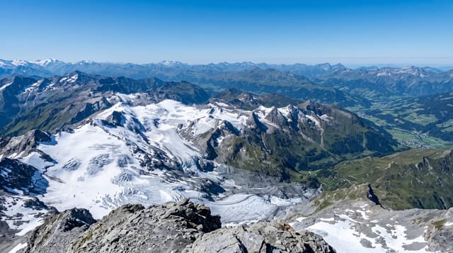
Hohe Tauern covers about eighteen hundred square kilometres across Salzburg, Tyrol and Carinthia, which makes it the largest protected area in the Alps; it was declared in stages from 1981 after decades of argument, largely over hydro schemes that would have flooded parts of it. Inside are the Grossglockner at 3,798 metres, the highest mountain in Austria, the Pasterze, the longest glacier in the eastern Alps and one that has lost more than half its volume since measurements began, the Krimml waterfalls, and a list of high valleys - Untersulzbachtal, Obersulzbachtal, Kalser Tal, Gschlösstal - that carry the walking. Wildlife includes ibex reintroduced in the 1960s, chamois, marmots, golden eagles and bearded vultures. The Grossglockner high alpine road crosses the park and is the way most visitors see it.
History
The park goes back to a declaration signed at Heiligenblut in 1971 by the three provinces, but the first parts, around the Grossglockner and the Hochschober in Carinthia, were protected only in 1981, and the neighbouring parts joined in 1992 (Wikipedia, Hohe Tauern National Park).
What you'll find
- The Grossglockner - Austria's highest mountain at 3,798 metres.
- The Pasterze glacier - the longest in the eastern Alps, and visibly retreating.
- High side valleys - Gschlösstal, Kalser Tal and the Sulzbach valleys for walking.
- Ibex and eagles - reintroduced ibex, chamois, golden eagles and vultures.
When to go
June to September; the high road closes for winter. Three days.
What to expect
The park is enormous and needs a base valley chosen in advance. The Grossglockner road is tolled and busy. High weather changes fast. The glacier viewpoints now show mostly rock and moraine.
Nearby
Krimml waterfalls, Heiligenblut and Zell am See are all at the edges.
Key facts
Source: Wikidata, item Q696014, read on 18 October 2026.
What to pack for Hohe Tauern National Park
Chosen from what this place is for. Tap a kit for the full checklist.
- Broken-in walking shoes or boots - Grip and ankle support matter more than looks; never hike in brand-new boots. Find on Amazon
- Binoculars - The single best wildlife tool - even a compact pair transforms a sighting. Find on Amazon
- Warm base layers - Merino or synthetic against the skin - never cotton, which chills when damp. Find on Amazon
- Layers for big temperature swings - Warm sun by day, near-freezing at night, even near the equator. Find on Amazon
Some links on this page are Amazon affiliate links - if you buy through them we may earn a small commission at no extra cost to you.
All packing kitsPlan your trip
Where to start if Hohe Tauern National Park is going on the list.
Booking links on this page are affiliate links - if you book through them we may earn a small commission at no extra cost to you. It never changes what we write about a place.
Opening times, ticket prices and seasonal closures change - check the official source before you go: official site.