Kaeng Tana National Park
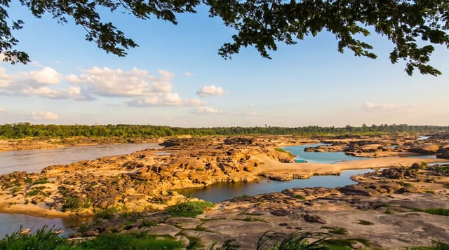
Rapids and water-sculpted rock islands on the lower Mun river, exposed only when the water drops.
Updated 21 October 2026
Kaeng Tana protects a stretch of the Mun river near its confluence with the Mekong, where the water runs over a bed of hard rock and has carved it into channels, potholes and islands. In the dry season, when the river drops, the rock emerges as a broad sculpted platform with the water running in narrow chutes between - the potholes, some of them deep and round, are drilled by stones spun by the current over long periods. A suspension bridge crosses to Don Tana, the largest island. In the wet season the whole formation is under water and there is essentially nothing to see, which is the key planning fact. The park also has forest trails, waterfalls in the wet months, and a Mekong viewpoint. The park was set up in 1981 and covers about 80 square kilometres; Don Tana island is some 700 metres long.
What's there
- The sculpted rock - channels, potholes and islands cut by the river.
- The potholes - round hollows drilled by stones spun in the current.
- The suspension bridge - crossing to Don Tana island.
- The seasonal exposure - the formation visible only when the water is low.
When to go
December to April, when the river is low and the rock is exposed. In the wet season the formation is submerged and there is little to see.
Before you go
Entirely season-dependent - a wet-season visit finds the rocks under water. The rock surface is slippery where wet. Basic facilities. Foreign entry fees are higher than Thai.
Nearby
Khong Chiam and the two-colour confluence are east; Ubon Ratchathani is west.
Key facts
Source: Wikidata, item Q6652894, read on 18 October 2026.
What to pack for Kaeng Tana National Park
Chosen from what this place is for. Tap a kit for the full checklist.
- Broken-in walking shoes or boots - Grip and ankle support matter more than looks; never hike in brand-new boots. Find on Amazon
- Binoculars - The single best wildlife tool - even a compact pair transforms a sighting. Find on Amazon
- Layers + a waterproof shell - Mountain weather turns fast; a packable rain jacket saves the day. Find on Amazon
- A zoom camera or long lens - Animals rarely come close; reach beats megapixels. Find on Amazon
Some links on this page are Amazon affiliate links - if you buy through them we may earn a small commission at no extra cost to you.
All packing kitsPlan your trip
Where to start if Kaeng Tana National Park is going on the list.
Booking links on this page are affiliate links - if you book through them we may earn a small commission at no extra cost to you. It never changes what we write about a place.
Opening times, ticket prices and seasonal closures change - check the official source before you go: official site.