Chapursan Valley
A remote Wakhi valley running towards the Afghan Wakhan, with stone villages, yak pastures and the shrine of Baba Ghundi at its head.
Updated 31 August 2026
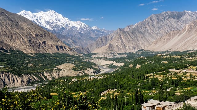
Chapursan branches west from the Karakoram Highway near Sost and runs for some eighty kilometres towards the Wakhan, a high, dry valley at over three thousand metres inhabited by Wakhi people whose language and culture connect across the borders to Afghanistan and Tajikistan. A string of small villages, Kirmin, Kil, Reshit, Yishkuk and Zood Khun among them, farm the irrigated patches and graze yaks on the pastures above. At the head of the valley stands the shrine of Baba Ghundi, a saint credited with bringing Islam to the valley, whose autumn festival gathers people from the whole region; beyond it the track fades towards the Irshad pass, an old route into the Wakhan used by Kyrgyz herders. Tourism is young here, built on homestays and a handful of guesthouses, and the valley offers a quieter, more domestic version of the high Karakoram than the trekking circuits.
What to look for
- Wakhi villages - stone and mud houses, irrigation channels and poplar stands.
- Baba Ghundi shrine - the pilgrimage site at the head of the valley.
- Yak pastures - herding grounds running towards the Irshad pass.
- Homestay life - meals and lodging in family houses.
When to go
June to September; the valley is high and cold, and the road can be cut by snow or floods outside midsummer. The Baba Ghundi festival in early autumn is the cultural high point. Nights are near freezing even in July.
Before you go
Facilities are minimal: homestays, basic food, no fuel beyond Sost, patchy solar power and no mobile signal for much of the valley. The road is rough and flood-prone. Visitors are guests in conservative villages and should dress and behave accordingly. This is a place for slow travel, not sightseeing.
Nearby
Sost and the Khunjerab road are at the valley mouth; Shimshal lies south.
Key facts
Source: Wikidata, item Q5101631, read on 18 October 2026.
What to pack for Chapursan Valley
Chosen from what this place is for. Tap a kit for the full checklist.
- Broken-in walking shoes or boots - Grip and ankle support matter more than looks; never hike in brand-new boots. Find on Amazon
- Warm base layers - Merino or synthetic against the skin - never cotton, which chills when damp. Find on Amazon
- Layers for big temperature swings - Warm sun by day, near-freezing at night, even near the equator. Find on Amazon
- Comfortable walking shoes - Sightseeing means kilometres of pavement and cobbles daily. Find on Amazon
Some links on this page are Amazon affiliate links - if you buy through them we may earn a small commission at no extra cost to you.
All packing kitsPlan your trip
Where to start if Chapursan Valley is going on the list.
Booking links on this page are affiliate links - if you book through them we may earn a small commission at no extra cost to you. It never changes what we write about a place.
Opening times, ticket prices and seasonal closures change - check the official source before you go: official site.