Ohope Beach
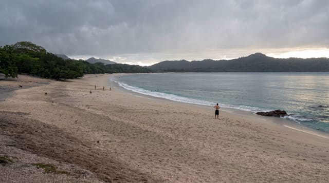
Eleven kilometres of sand near Whakatane, repeatedly voted the country's best beach, with a bird-rich harbour behind.
Updated 27 August 2026
Ohope runs about eleven kilometres east from the Whakatane heads, north-facing, gently shelving and backed by pohutukawa and holiday houses rather than dunes - which is why it swims easily and why it keeps winning the national beach polls. The surf club patrols the western end in summer. Behind the spit lies Ohiwa Harbour, a shallow tidal estuary that is one of the better wader and shorebird sites in the North Island, with a walkway around parts of it and shellfish beds that are gathered under seasonal rules. At the western end, Otarawairere Bay is reached only on foot over the headland from Ohope or Whakatane, a walk of about an hour that ends at a small enclosed bay most visitors never see. Whakatane itself is the departure point for Whakaari trips, which have not operated since 2019.
What's there
- The eleven-kilometre beach - north-facing, gentle, patrolled in season.
- Ohiwa Harbour - the tidal estuary behind, rich in shorebirds.
- Otarawairere Bay - the hidden cove reached only on foot.
- The pohutukawa fringe - the tree line along the back of the sand.
When to go
December to March for swimming; the harbour birds are best on a rising tide year round. January is the one crowded month.
Before you go
Swim between the flags at the patrolled end; the rest of eleven kilometres is unsupervised. Shellfish gathering has legal limits and seasonal closures. The Otarawairere walk is steep in places and partly tidal.
Nearby
Whakatane is over the hill; Ohiwa Harbour and Opotiki are east.
What to pack for Ohope Beach
Chosen from what this place is for. Tap a kit for the full checklist.
- Reef-safe sunscreen - High SPF that will not bleach the coral you are swimming over. Find on Amazon
- Quick-dry clothing - Board shorts or synthetics that shrug off spray and dry fast. Find on Amazon
- Loose, light, long clothing - Covering up beats bare skin in the desert - and locals dress this way for a reason. Find on Amazon
- Quick-dry towel - A microfibre towel packs small and dries in minutes. Find on Amazon
Some links on this page are Amazon affiliate links - if you buy through them we may earn a small commission at no extra cost to you.
All packing kitsPlan your trip
Where to start if Ohope Beach is going on the list.
Booking links on this page are affiliate links - if you book through them we may earn a small commission at no extra cost to you. It never changes what we write about a place.
Opening times, ticket prices and seasonal closures change - check the official source before you go: official site.