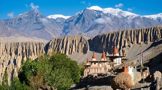
Kali Gandaki Gorge
The valley between Annapurna and Dhaulagiri, cut so deep that both 8,000-metre peaks stand above it some 34 km apart.
Updated 21 October 2026
The Kali Gandaki runs south between Dhaulagiri at 8,167 metres and Annapurna I at 8,091 metres, with the two summits standing about 34 kilometres apart and the river bed between them at around 2,500 metres near Tukuche, which is the measurement behind the claim that this is the world's deepest gorge, though how you define the rim of a valley makes the ranking arguable. What is not arguable is the scale, or the fact that the river is older than the range it cuts through, having kept its course as the mountains rose. The valley is also the source of shaligrams, the black ammonite fossils venerated as forms of Vishnu and collected from the river bed, and it has been a salt and trade route between India and Tibet for centuries.
History
The upper part of the gorge is called Thak Khola after the Thakali people, who grew prosperous from trade across the Himalaya. Between Dhaulagiri and Annapurna I the river runs at 2,520 metres, 5,571 metres below the summit of Annapurna I, having cut down through the mountains as they rose, and the area is known for the shaligram fossils revered by Hindus as a form of Vishnu (Wikipedia, Kali Gandaki Gorge).
The landscape
- The valley walls - Dhaulagiri and Annapurna on either side of one river.
- Shaligram fossils - the black ammonites found in the river bed.
- The trade route - the old salt road villages along the valley.
- Tatopani hot springs - the pools at the southern end of the gorge.
When to go
October to November and March to May. The rain shadow keeps the upper valley drier through the monsoon, but the lower gorge is wet and landslide-prone. Strong up-valley wind blows every afternoon year round.
Practical notes
The road built up the valley has taken over much of the old trekking trail, and jeeps, dust and blasting are now part of the experience. The deepest-gorge claim depends on how the measurement is drawn. Collecting shaligrams from the river is restricted. Afternoon wind is severe.
Nearby
Marpha and Jomsom lie north; Beni is at the southern end.
Key facts
Source: Wikidata, item Q5769166, read on 18 October 2026.
What to pack for Kali Gandaki Gorge
Chosen from what this place is for. Tap a kit for the full checklist.
- Broken-in walking shoes or boots - Grip and ankle support matter more than looks; never hike in brand-new boots. Find on Amazon
- Strong insect repellent - DEET or picaridin; the jungle is where bites and disease risk are highest. Find on Amazon
- Layers for big temperature swings - Warm sun by day, near-freezing at night, even near the equator. Find on Amazon
- Swimwear - Needed at most public thermal pools; some traditional baths are nude and single-sex. Find on Amazon
Some links on this page are Amazon affiliate links - if you buy through them we may earn a small commission at no extra cost to you.
All packing kitsPlan your trip
Where to start if Kali Gandaki Gorge is going on the list.
Booking links on this page are affiliate links - if you book through them we may earn a small commission at no extra cost to you. It never changes what we write about a place.
Opening times, ticket prices and seasonal closures change - check the official source before you go: official site.