Black Valley
A glacial valley under the Reeks that was the last place in Ireland to get electricity, in 1976.
Updated 21 October 2026
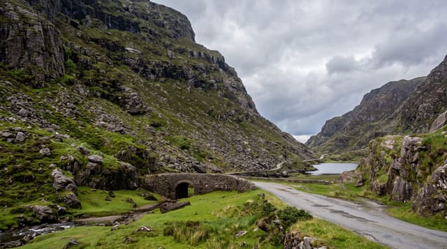
Cummeenduff, the Black Valley, runs west from the foot of the Gap of Dunloe beneath the southern wall of the MacGillycuddy's Reeks. Ice cut it deep and left a chain of small lakes along the floor with almost no flat ground beside them, which is why it has never held more than a handful of households. It is best known for having been the last inhabited place in Ireland connected to the electricity grid, in 1976, the same year the telephone arrived. The name most likely comes from the shadow: the Reeks stand high enough on the northern side that parts of the valley get very little direct sun in winter. The Kerry Way walking route runs through, and there is a hostel and a church. Roads in are single-track with grass down the middle and passing places; the through route from the Gap of Dunloe is a hard drive and not one to attempt in a large vehicle.
What's there
- The glacial floor - a chain of small lakes with steep walls either side.
- The Reeks above - the southern face of Ireland's highest range.
- The isolation - the last place in Ireland to get mains electricity, in 1976.
- The Kerry Way - the long-distance path running through the valley.
When to go
May to September. The valley is shaded and cold in winter. Roads are single-track and difficult in poor weather or after dark.
What to expect
Single-track roads with passing places and no room for large vehicles; the descent from the Gap of Dunloe is steep and rough. Almost no services - one hostel, no shop, no fuel. Phone coverage is poor to absent.
Nearby
The Gap of Dunloe is at the northern end; Moll's Gap and the N71 are east.
Key facts
Source: Wikidata, item Q7718467, read on 18 October 2026.
What to pack for Black Valley
Chosen from what this place is for. Tap a kit for the full checklist.
- Broken-in walking shoes or boots - Grip and ankle support matter more than looks; never hike in brand-new boots. Find on Amazon
- Layers + a waterproof shell - Mountain weather turns fast; a packable rain jacket saves the day. Find on Amazon
- Daypack with rain cover - 20-30 litres holds water, snacks, layers and a first-aid kit. Find on Amazon
- Offline maps + a power bank - Download the trail before you lose signal; carry backup charge. Find on Amazon
Some links on this page are Amazon affiliate links - if you buy through them we may earn a small commission at no extra cost to you.
All packing kitsPlan your trip
Where to start if Black Valley is going on the list.
Booking links on this page are affiliate links - if you book through them we may earn a small commission at no extra cost to you. It never changes what we write about a place.
Opening times, ticket prices and seasonal closures change - check the official source before you go: official site.