Cape Three Points
The southernmost point of Ghana, a lighthouse headland with forest reserve behind it and a long rough approach.
Updated 1 September 2026
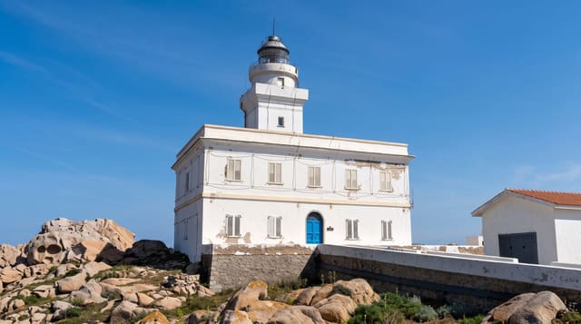
Cape Three Points is the southernmost land in Ghana, a headland of three low promontories where the coast turns, and the point closest to the intersection of the equator and the prime meridian, which is the fact the signboards make much of. A lighthouse built in 1925 stands on the cape and can sometimes be climbed with the keeper's permission for the view along the coast in both directions. Behind it a small forest reserve holds one of the last patches of coastal rainforest in the country, with monkeys and birds. The approach is a rough track from Akwidaa or Princes Town, and the villages nearby are fishing settlements with a few very simple places to stay.
What you'll find
- The lighthouse - the 1925 tower on the southernmost headland.
- The three promontories - the low points that name the cape.
- The forest reserve - the coastal rainforest patch behind the cape.
- Fishing villages - Akwidaa and the settlements on the approach.
When to go
November to March in the dry season; the tracks are difficult or impassable after rain. Mornings are cooler for walking and for wildlife in the forest behind.
Things to know
The approach roads are genuinely rough and a four-wheel drive or a long walk is needed. Lighthouse access depends on the keeper being present and willing. Facilities are minimal. Currents on the surrounding beaches are dangerous.
Nearby
Akwidaa and Butre lie east; Princes Town is west.
Key facts
Source: Wikidata, item Q1261417, read on 18 October 2026.
What to pack for Cape Three Points
Chosen from what this place is for. Tap a kit for the full checklist.
- Travel rod + reel - A packable multi-piece rod fits in a case and covers most holiday fishing. Find on Amazon
- Reef-safe sunscreen - High SPF that will not bleach the coral you are swimming over. Find on Amazon
- Binoculars - The single best wildlife tool - even a compact pair transforms a sighting. Find on Amazon
- Strong insect repellent - DEET or picaridin; the jungle is where bites and disease risk are highest. Find on Amazon
Some links on this page are Amazon affiliate links - if you buy through them we may earn a small commission at no extra cost to you.
All packing kitsPlan your trip
Where to start if Cape Three Points is going on the list.
Booking links on this page are affiliate links - if you book through them we may earn a small commission at no extra cost to you. It never changes what we write about a place.
Opening times, ticket prices and seasonal closures change - check the official source before you go: official site.