Truso Valley
A high valley of mineral springs, travertine terraces and abandoned stone villages.
Updated 31 August 2026
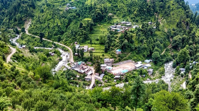
The Truso valley runs west from the Georgian Military Highway below Kazbegi, following the young Terek through a gorge that opens into a broad high valley at around two thousand metres, and what makes it strange is the water: carbonated mineral springs rise all along the floor, staining the ground orange and red and building travertine mounds and terraces, with the largest, at Abano, forming a rusty dome beside the river. Stone villages stand along the sides, most of them empty, and the ruined tower of Zakagori sits on a bluff above. It is walked or driven in from the road, roughly fifteen kilometres to the far end, and the valley is a controlled border zone.
What's there
- Travertine terraces at Abano - mineral mounds built by the springs.
- Orange and red staining - iron and carbonate along the valley floor.
- Zakagori fortress - the tower on the bluff above the river.
- Abandoned stone villages - the settlements along the valley sides.
When to go
June to September; snow closes the valley for much of the year. A day. Carry identification: this is a border zone with checks, and the far end may be closed.
Practical notes
It is a border area and access can be restricted or refused; carry a passport. The road in is rough and needs a proper vehicle. Walking the full length and back is a long day. There are no facilities and no shelter if weather turns.
Nearby
Kazbegi is north; the Georgian Military Highway runs past the entrance.
Key facts
Source: Wikidata, item Q957561, read on 18 October 2026.
What to pack for Truso Valley
Chosen from what this place is for. Tap a kit for the full checklist.
- Broken-in walking shoes or boots - Grip and ankle support matter more than looks; never hike in brand-new boots. Find on Amazon
- Warm base layers - Merino or synthetic against the skin - never cotton, which chills when damp. Find on Amazon
- Layers + a waterproof shell - Mountain weather turns fast; a packable rain jacket saves the day. Find on Amazon
- An insulated + windproof jacket - A down or synthetic layer under a hard shell handles most cold. Find on Amazon
Some links on this page are Amazon affiliate links - if you buy through them we may earn a small commission at no extra cost to you.
All packing kitsPlan your trip
Where to start if Truso Valley is going on the list.
Booking links on this page are affiliate links - if you book through them we may earn a small commission at no extra cost to you. It never changes what we write about a place.
Opening times, ticket prices and seasonal closures change - check the official source before you go: official site.