Mount Tomanivi
The highest mountain in Fiji at 1,324 metres, climbed from Navai village through cloud forest to a summit usually in mist.
Updated 1 September 2026
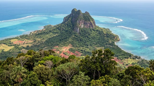
Tomanivi, sometimes called Mount Victoria, rises to 1,324 metres in the middle of Viti Levu and is the highest point in Fiji. The climb starts from Navai village on the cross-island road and goes up through farmland into cloud forest, steep and muddy, with roots and rock scrambling in the upper section. It takes three to four hours up. The summit is small and more often than not sits inside cloud, which is what keeps the forest on it wet.
What's there
- The summit - 1,324 metres, the highest ground in Fiji.
- The cloud forest - wet mossy forest through the upper slopes.
- The scramble - roots and rock on the steep final section.
- Navai village - the starting point, where permission and a guide are arranged.
When to go
May to October is the drier season and the only sensible window. The mountain is wet in any month and the summit is usually in cloud. Starting early gives the best chance of a view.
Practical notes
The climb is steep, muddy and slippery, and it is harder than the modest altitude suggests. A guide from Navai is required, both for the route and because the land is owned. Views from the top are the exception rather than the rule.
Nearby
Navai is on the cross-island road, and Nadarivatu is a short way north.
Key facts
Source: Wikidata, item Q1513944, read on 18 October 2026.
What to pack for Mount Tomanivi
Chosen from what this place is for. Tap a kit for the full checklist.
- Broken-in walking shoes or boots - Grip and ankle support matter more than looks; never hike in brand-new boots. Find on Amazon
- Layers for big temperature swings - Warm sun by day, near-freezing at night, even near the equator. Find on Amazon
- Layers + a waterproof shell - Mountain weather turns fast; a packable rain jacket saves the day. Find on Amazon
- Extra-strong sun protection - Thin air means fierce UV; hat, sunglasses and high-SPF sunscreen. Find on Amazon
Some links on this page are Amazon affiliate links - if you buy through them we may earn a small commission at no extra cost to you.
All packing kitsPlan your trip
Where to start if Mount Tomanivi is going on the list.
Booking links on this page are affiliate links - if you book through them we may earn a small commission at no extra cost to you. It never changes what we write about a place.
Opening times, ticket prices and seasonal closures change - check the official source before you go: official site.