Montville
A crafts and cottage village on the Blackall Range, looking east over the Sunshine Coast from five hundred metres up.
Updated 18 October 2026

AI illustration
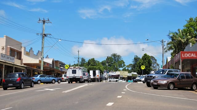
Montville sits on the ridge of the Blackall Range at around five hundred metres, high enough for a noticeably cooler climate than the coast below, and its main street is a run of timber cottages and mock-Tudor shopfronts holding galleries, sweet shops, cafés and craft stores, with a lookout at the end of the street giving a long view east over the coastal plain to the Pacific. The village grew as a farming settlement and was already a popular mountain resort from about 1900. Nearby, Kondalilla Falls drops around ninety metres into rainforest on a circuit walk, Baroon Pocket Dam offers kayaking, and the range road continues south to Maleny through dairy country.
History
The first settlers came in 1887 to a place then called Razorback, and the new name, mountain village, was officially adopted on 30 November 1897, perhaps suggested by the storekeeper Henry Smith's mother, who was reminded of Montville in the United States. From about 1900 the town was a popular mountain resort, the Methodist church was built in 1912 and St Mary's Anglican in 1914, and it lived from logging and then farming (Wikipedia, Montville, Queensland).
The main sights
- The village street - timber and mock-Tudor shopfronts of galleries and cafés.
- The coastal view - the escarpment lookout over the Sunshine Coast.
- Kondalilla Falls - a ninety-metre fall on a rainforest circuit nearby.
- The range drive - the ridge road through dairy country to Maleny.
When to go
April to October for clear, dry weather; summer brings humidity and afternoon storms, and cloud often sits on the range. Weekends are busy with day trippers and parking on the main street is difficult.
Good to know
The village is small and thoroughly geared to visitors, which reads as charming or twee depending on taste. The whole street takes an hour. Roads up the range are narrow and winding, and weekend traffic is slow.
Nearby
Maleny lies south along the range; Kondalilla and Baroon Pocket are minutes away.
Key facts
Source: Wikidata, item Q6906660, read on 18 October 2026.
What to pack for Montville
Chosen from what this place is for. Tap a kit for the full checklist.
- Quick-dry clothing - Board shorts or synthetics that shrug off spray and dry fast. Find on Amazon
- Strong insect repellent - DEET or picaridin; the jungle is where bites and disease risk are highest. Find on Amazon
- Comfortable walking shoes - Sightseeing means kilometres of pavement and cobbles daily. Find on Amazon
- Secure water shoes or reef boots - Grip on slippery launches and protection on rocky shores. Find on Amazon
Some links on this page are Amazon affiliate links - if you buy through them we may earn a small commission at no extra cost to you.
All packing kitsPlan your trip
Where to start if Montville is going on the list.
Booking links on this page are affiliate links - if you book through them we may earn a small commission at no extra cost to you. It never changes what we write about a place.
Opening times, ticket prices and seasonal closures change - check the official source before you go: official site.