Ruta de los Seismiles
A high desert highway from Fiambalá to the Chilean border that runs past a dozen volcanoes over 6,000 metres, among the highest roads on Earth.
Updated 1 October 2026
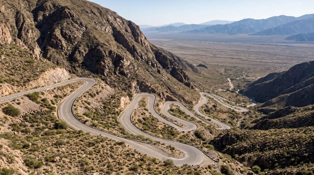
The Ruta de los Seismiles is the name given to the stretch of RN60 that climbs west from Fiambalá to the Paso San Francisco at around 4,750 metres, and it takes its name from the wall of six-thousand-metre volcanoes it passes: Incahuasi, El Fraile, San Francisco, Nacimientos and others, with Ojos del Salado, the highest volcano on Earth, straddling the border just south of the pass. The road climbs through desert and lava into a landscape of coloured mineral slopes, salt flats, and lagoons where vicuñas graze and flamingos feed, notably the Laguna Verde near the pass. There is no settlement, no fuel and no signal for hundreds of kilometres, and the weather at the top is severe in any season, which is why the drive counts as an expedition rather than an outing.
What to look for
- The six-thousanders - a line of volcanoes over 6,000 metres along the route.
- Laguna Verde - the high lagoon near the pass with flamingos and vicuñas.
- The mineral slopes - coloured rock and salt flats on the altiplano.
- Paso San Francisco - the border crossing at around 4,750 metres.
When to go
The pass is most reliable from December to March; in winter snow closes it for long spells. Even in summer, storms arrive fast. Always check the crossing status before leaving Fiambalá, and never drive it in the dark.
Things to know
There is no fuel between Fiambalá and Copiapó in Chile, a distance that exceeds many vehicles' range, so extra fuel is essential. Altitude at the pass affects nearly everyone, and vehicles lose power. Breakdowns here are dangerous, and traffic is very light.
Nearby
Fiambalá is the last base; the Chilean side descends toward Copiapó and the Atacama.
What to pack for Ruta de los Seismiles
Chosen from what this place is for. Tap a kit for the full checklist.
- Reef-safe sunscreen - High SPF that will not bleach the coral you are swimming over. Find on Amazon
- Warm base layers - Merino or synthetic against the skin - never cotton, which chills when damp. Find on Amazon
- Loose, light, long clothing - Covering up beats bare skin in the desert - and locals dress this way for a reason. Find on Amazon
- Layers for big temperature swings - Warm sun by day, near-freezing at night, even near the equator. Find on Amazon
Some links on this page are Amazon affiliate links - if you buy through them we may earn a small commission at no extra cost to you.
All packing kitsPlan your trip
Where to start if Ruta de los Seismiles is going on the list.
Booking links on this page are affiliate links - if you book through them we may earn a small commission at no extra cost to you. It never changes what we write about a place.
Opening times, ticket prices and seasonal closures change - check the official source before you go: official site.