Columbia River Gorge
A 130-kilometre canyon cut by ice age floods, holding the densest concentration of waterfalls in the country.
Updated 16 October 2026
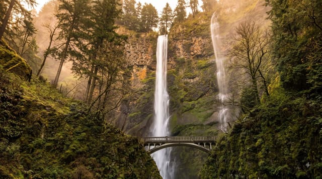
The gorge is the only near-sea-level route through the Cascade Range, cut deeper by the Missoula Floods - a series of catastrophic ice age outburst floods that scoured it repeatedly, leaving hanging valleys whose streams now fall directly off the walls. That is why there are so many waterfalls in so short a distance, Multnomah Falls at about 189 metres the tallest. The Historic Columbia River Highway, opened 1916, was built deliberately as a scenic road with stone parapets and easy grades. The gorge also funnels wind reliably, which made Hood River a windsurfing centre. The Eagle Creek Fire in 2017 burned about 190 square kilometres and closed trails for years; some remain shut.
Background
The gorge is up to 4,000 feet deep and runs for over 80 miles as the Columbia winds west through the Cascade Range, and the river here divides Oregon on the south bank from Washington on the north. It stretches from the river's confluence with the Deschutes, near Roosevelt and Arlington, to the eastern edge of the Portland area, and no other route lets boats cross the Cascades, so it is the one water link between the Columbia Plateau and the Pacific. Interstate 84, U.S. Route 30, Washington State Route 14 and railways on both banks follow it. Since 1986 it has been protected as a National Scenic Area.
Source: Wikipedia, "Columbia River Gorge"
The landscape
- Waterfalls off hanging valleys - the flood-scoured walls left them.
- Multnomah Falls - about 189 metres, the tallest.
- The 1916 scenic highway - stone parapets and gentle grades.
- Reliable funnelled wind - the basis of Hood River windsurfing.
When to go
April to October; waterfalls are fullest in spring. A full day.
Things to know
Multnomah Falls requires a timed permit in the busy season. Fire damage from 2017 has closed trails, some permanently. Winter ice storms close the highway. East winds in winter are severe.
Nearby
Hood River is east; Portland is west.
Key facts
Source: Wikidata, item Q1112581, read on 18 October 2026.
What to pack for Columbia River Gorge
Chosen from what this place is for. Tap a kit for the full checklist.
- Broken-in walking shoes or boots - Grip and ankle support matter more than looks; never hike in brand-new boots. Find on Amazon
- Quick-dry clothing - Board shorts or synthetics that shrug off spray and dry fast. Find on Amazon
- Layers + a waterproof shell - Mountain weather turns fast; a packable rain jacket saves the day. Find on Amazon
- Secure water shoes or reef boots - Grip on slippery launches and protection on rocky shores. Find on Amazon
Some links on this page are Amazon affiliate links - if you buy through them we may earn a small commission at no extra cost to you.
All packing kitsPlan your trip
Where to start if Columbia River Gorge is going on the list.
Booking links on this page are affiliate links - if you book through them we may earn a small commission at no extra cost to you. It never changes what we write about a place.
Opening times, ticket prices and seasonal closures change - check the official source before you go: official site.