Malham Cove
A curved limestone wall eighty metres high with a pavement of fissured blocks on top, and a waterfall that ran in 2015 for the first time since 1824.
Updated 20 October 2026
AI illustration
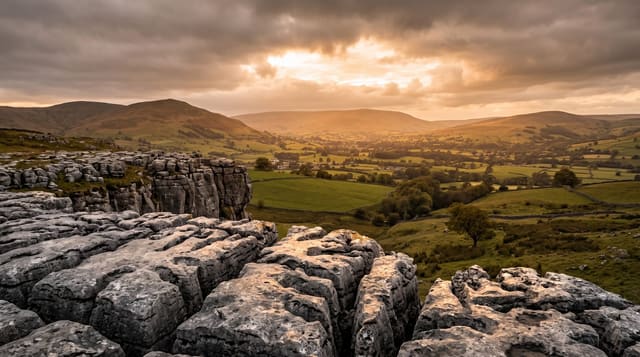
The cove is a cliff of Great Scar limestone about eighty metres high and three hundred wide, curved like an amphitheatre, formed along the Mid-Craven Fault and cut back by meltwater at the end of the last glaciation. Above it lies one of the best limestone pavements in Britain, blocks called clints separated by deep fissures called grykes, in which ferns and rare lime-loving plants grow sheltered from grazing. A large waterfall once fell over the lip and has not flowed in normal conditions for centuries; it ran briefly on 6 December 2015 during Storm Desmond, believed to be the first time since 1824. Peregrines nest on the face and the RSPB runs a seasonal watchpoint. The pavement was used as a filming location in a Harry Potter film.
The landscape
- The eighty-metre curved face - a limestone amphitheatre on the Craven Fault.
- The limestone pavement - clints and grykes with rare plants in the fissures.
- The peregrine watchpoint - RSPB telescopes on the nesting face in season.
- The dry waterfall lip - where water fell in 2015 for the first time since 1824.
When to go
April to October; peregrines are watched from April to July. The pavement is slippery and genuinely dangerous when wet or frosted, so dry days are much safer for walking on it.
Good to know
The four hundred steps up the side of the cove are steep and uneven. The pavement's grykes are deep enough to break a leg and are hidden by vegetation in summer. Malham village parking fills early on weekends and the walk in is on a busy path.
Nearby
Gordale Scar and Janet's Foss are a short walk; Settle and the Ribble valley lie west.
Key facts
Source: Wikidata, item Q1789790, read on 18 October 2026.
What to pack for Malham Cove
Chosen from what this place is for. Tap a kit for the full checklist.
- Broken-in walking shoes or boots - Grip and ankle support matter more than looks; never hike in brand-new boots. Find on Amazon
- Layers + a waterproof shell - Mountain weather turns fast; a packable rain jacket saves the day. Find on Amazon
- Daypack with rain cover - 20-30 litres holds water, snacks, layers and a first-aid kit. Find on Amazon
- Offline maps + a power bank - Download the trail before you lose signal; carry backup charge. Find on Amazon
Some links on this page are Amazon affiliate links - if you buy through them we may earn a small commission at no extra cost to you.
All packing kitsPlan your trip
Where to start if Malham Cove is going on the list.
Booking links on this page are affiliate links - if you book through them we may earn a small commission at no extra cost to you. It never changes what we write about a place.
Opening times, ticket prices and seasonal closures change - check the official source before you go: official site.