Lopit Mountains
A range in the southeast with villages built high on the slopes.
Updated 14 October 2026
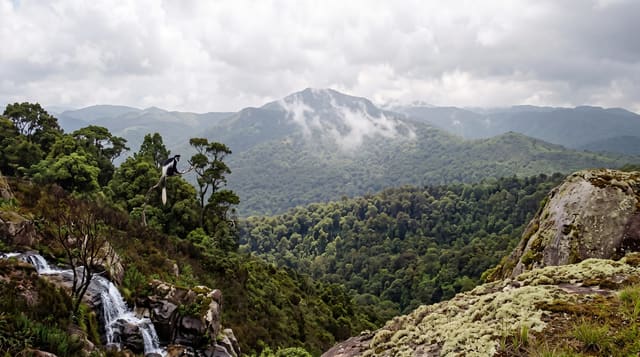
The Lopit mountains rise northeast of Torit in southeastern South Sudan, a range where the Lopit people built their villages high on the slopes rather than on the plain below, terracing the hillsides for sorghum and keeping the settlements above the valley floor. The stone-built villages climb the ridges and the country is green compared with the plains around. Building high on the slopes kept the villages away from the flooding and the mosquitoes of the plain below.
What's there
- The hillside villages - Lopit settlements built high on the slopes.
- The terracing - the cultivation worked up the hillsides.
- The stone building - the construction the villages use.
- The green range - highland catching rain the plains do not.
When to go
December to March is the dry season and tracks are passable. The rains from April make access very difficult. The hills stay green longer than the plains.
What to expect
Access needs guides, community permission and four wheel drive on rough tracks, then walking. There is no infrastructure. Travel in this region requires arrangement well ahead.
Nearby
Torit is southwest, and the Imatong mountains are south.
What to pack for Lopit Mountains
Chosen from what this place is for. Tap a kit for the full checklist.
- Broken-in walking shoes or boots - Grip and ankle support matter more than looks; never hike in brand-new boots. Find on Amazon
- Layers for big temperature swings - Warm sun by day, near-freezing at night, even near the equator. Find on Amazon
- Layers + a waterproof shell - Mountain weather turns fast; a packable rain jacket saves the day. Find on Amazon
- Extra-strong sun protection - Thin air means fierce UV; hat, sunglasses and high-SPF sunscreen. Find on Amazon
Some links on this page are Amazon affiliate links - if you buy through them we may earn a small commission at no extra cost to you.
All packing kitsPlan your trip
Where to start if Lopit Mountains is going on the list.
Booking links on this page are affiliate links - if you book through them we may earn a small commission at no extra cost to you. It never changes what we write about a place.
Opening times, ticket prices and seasonal closures change - check the official source before you go: official site.