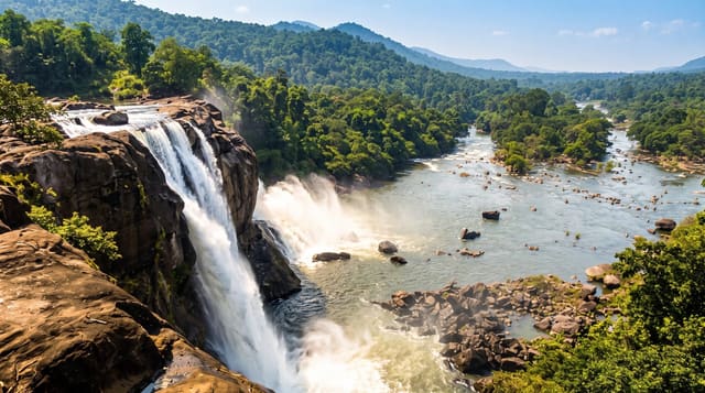
Marokopa Falls
A thirty-five metre curtain over a wide rock lip west of Waitomo, five minutes from the road and often empty.
Updated 27 August 2026
The Marokopa River drops about thirty-five metres over a broad ledge into a bush-walled amphitheatre, spreading across the full width of the rock rather than falling in a single column, which is why it is often described as one of the more beautiful falls in the country and why photographs of it look wider than tall. The walk is five to ten minutes from a small roadside car park on a good track through tawa forest to a viewing platform; you look at it from across the gorge rather than from the base, and there is no legitimate way down to the pool. It sits on the Te Anga Road, the winding route west from Waitomo toward the coast, and the sensible way to see it is as one of three stops with Mangapohue Natural Bridge and the Piripiri Caves, all within a few kilometres. After rain the fall is heavy and loud; in a dry summer it thins noticeably.
What's there
- The thirty-five metre curtain - spread across the full rock lip.
- The viewing platform - across the gorge, five minutes from the road.
- The tawa forest - the short bush track in.
- The Te Anga road stops - natural bridge and caves nearby.
When to go
Any season; after rain it is at its most impressive. The road is winding and slow - allow more time than the distance suggests.
Practical notes
You view from a platform across the gorge; there is no access to the base and scrambling down is dangerous. Thirty minutes covers it. The car park is small and the road narrow.
Nearby
Mangapohue Natural Bridge and Piripiri Caves are on the same road; Waitomo is east.
Key facts
Source: Wikidata, item Q6772297, read on 18 October 2026.
What to pack for Marokopa Falls
Chosen from what this place is for. Tap a kit for the full checklist.
- Broken-in walking shoes or boots - Grip and ankle support matter more than looks; never hike in brand-new boots. Find on Amazon
- Head torch + spare batteries - Hands-free light is essential; caves are truly dark. Find on Amazon
- Layers + a waterproof shell - Mountain weather turns fast; a packable rain jacket saves the day. Find on Amazon
- Grippy closed shoes - Cave floors are wet, muddy and slick with formations. Find on Amazon
Some links on this page are Amazon affiliate links - if you buy through them we may earn a small commission at no extra cost to you.
All packing kitsPlan your trip
Where to start if Marokopa Falls is going on the list.
Booking links on this page are affiliate links - if you book through them we may earn a small commission at no extra cost to you. It never changes what we write about a place.
Opening times, ticket prices and seasonal closures change - check the official source before you go: official site.