Inhaca Island
A coral island in Maputo Bay with a long-established marine research station and some of the southernmost reefs in Africa.
Updated 20 October 2026
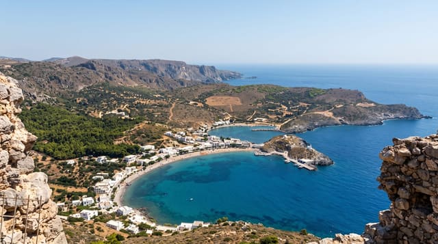
Inhaca closes the eastern side of Maputo Bay, an island of around fifty square kilometres with dune forest, mangrove and coral reefs that are among the southernmost in the western Indian Ocean, which makes them scientifically interesting: they sit at the limit of where reef-building corals can survive. A marine biology station run by the university has operated here since 1951 and has a small museum. Fringing reefs on the eastern side are the diving and snorkelling.
History
Although it belonged to Portuguese Mozambique, the island was held by the British from 1823 until the MacMahon Treaty of 24 July 1875, as one of the bases from which they patrolled against the slave trade (Wikipedia, Inhaca Island).
What you'll find
- The southern reefs - among the southernmost coral reefs in the western Indian Ocean.
- The research station - a marine biology station operating since 1951, with a museum.
- The mangroves - stands on the sheltered western side of the island.
- The dune forest - coastal forest across the island's interior.
When to go
May to September is the cooler dry season and the best for diving visibility. Summer from November to March is hot and humid with more rain. Ferry crossings depend on conditions.
What to expect
The ferry is slow and uncomfortable and the schedule is unreliable; flights are quick but expensive. Accommodation on the island is limited and basic for the price. Reef condition has declined from bleaching and pressure.
Nearby
Maputo is across the bay, and Ponta do Ouro is south down the coast.
Key facts
Source: Wikidata, item Q2306773, read on 18 October 2026.
What to pack for Inhaca Island
Chosen from what this place is for. Tap a kit for the full checklist.
- Reef-safe sunscreen - High SPF that will not bleach the coral you are swimming over. Find on Amazon
- Your own mask + snorkel - A well-fitting mask is the single biggest comfort upgrade underwater. Find on Amazon
- Loose, light, long clothing - Covering up beats bare skin in the desert - and locals dress this way for a reason. Find on Amazon
- Strong insect repellent - DEET or picaridin; the jungle is where bites and disease risk are highest. Find on Amazon
Some links on this page are Amazon affiliate links - if you buy through them we may earn a small commission at no extra cost to you.
All packing kitsPlan your trip
Where to start if Inhaca Island is going on the list.
Booking links on this page are affiliate links - if you book through them we may earn a small commission at no extra cost to you. It never changes what we write about a place.
Opening times, ticket prices and seasonal closures change - check the official source before you go: official site.