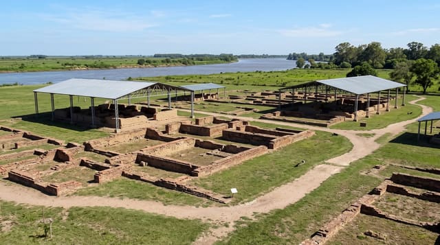
Dos Pilas
A Petexbatun site whose hieroglyphic stairway records a century of warfare between Maya kingdoms.
Updated 19 October 2026
Dos Pilas was founded in the seventh century by a branch of the Tikal dynasty and then fought against its parent city, and the record of that is carved into the site: a hieroglyphic stairway whose steps set out in detail the wars, captures and alliances of its rulers over roughly a century, one of the fullest historical texts surviving from the Maya world. Reading it transformed understanding of how competitive and violent the political landscape of the Classic period was. The city was eventually abandoned and its people built defensive walls from the stones of their own buildings. Structures stand in forest with the stairway sheltered.
History
In AD 629 the Tikal king K'inich Muwaan Jol II installed his four-year-old son B'alaj Chan K'awiil as ruler of Dos Pilas to control trade on the Pasión River, and the new city adopted Tikal's emblem glyph. In AD 648 Yuknoom Ch'een II of Calakmul defeated Dos Pilas and captured B'alaj Chan K'awiil, then put him back on the throne as his vassal, and from then on the city served Calakmul, Tikal's sworn enemy; in AD 672 Nuun Ujol Chaak of Tikal took the city and drove B'alaj Chan K'awiil into exile until AD 677 (Wikipedia, Dos Pilas).
What's there
- The hieroglyphic stairway - a detailed carved record of Maya warfare.
- Defensive walls of reused stone - buildings dismantled to fortify the city.
- Forested plazas and palaces - the site under jungle cover.
- A dynasty that fought its parent city - the history the texts record.
When to go
January to April, the dry season; the track is impassable in the rains. A day from Sayaxche. Guides are required and arranged locally.
What to expect
Access is difficult and needs a guide, a vehicle and a walk. Much of the site is unrestored. Carvings are weathered and under shelters. Insects, mud and heat are constant.
Nearby
Aguateca is east; Sayaxche lies north.
Key facts
Source: Wikidata, item Q909286, read on 18 October 2026.
What to pack for Dos Pilas
Chosen from what this place is for. Tap a kit for the full checklist.
- Strong insect repellent - DEET or picaridin; the jungle is where bites and disease risk are highest. Find on Amazon
- Comfortable walking shoes - Sightseeing means kilometres of pavement and cobbles daily. Find on Amazon
- Long, light, quick-dry clothing - Covers skin from insects and sun without cooking you in the humidity. Find on Amazon
- A slim anti-theft daypack - Zips that close properly; keep it in front in crowds and on transit. Find on Amazon
Some links on this page are Amazon affiliate links - if you buy through them we may earn a small commission at no extra cost to you.
All packing kitsPlan your trip
Where to start if Dos Pilas is going on the list.
Booking links on this page are affiliate links - if you book through them we may earn a small commission at no extra cost to you. It never changes what we write about a place.
Opening times, ticket prices and seasonal closures change - check the official source before you go: official site.