Ile de Re
A flat island of whitewashed houses and green shutters, crossed by about a hundred kilometres of cycle path.
Updated 19 October 2026

AI illustration
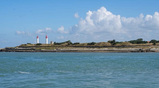
Re is about thirty kilometres long and almost entirely flat, which with roughly a hundred kilometres of dedicated cycle path makes the bicycle the obvious way to move; families ride between the ten villages, which are held to a strict code of whitewashed walls, low roofs and green or grey shutters. Salt has been harvested here since the Middle Ages and the pans still work in the north of the island, producing coarse salt and fleur de sel. Saint-Martin-de-Re is fortified by Vauban and UNESCO listed with his other works. Donkeys were once dressed in striped trousers to protect them from marsh flies, a habit the island keeps as a curiosity.
History
In Roman times Ré was three small islands, joined over time by salt pans won from the sea and by silting. In the 7th and 8th centuries it formed with Oléron the Vacetian Islands, suggesting Basque control, in 745 Duke Hunald of Aquitaine retired to a monastery here, and in the mid-12th century a Cistercian abbey was founded where Isaac of Stella stayed. The island became English in 1154 with Eleanor of Aquitaine's marriage, returned to France in 1243, and was briefly English again from 1360 into the 1370s; its fishing locks, stone traps that hold fish as the tide falls, were built between the 13th and 15th centuries. In 1625 the Huguenot Duke of Soubise seized the island, and in 1627 the Duke of Buckingham besieged the citadel of Saint-Martin for three months to relieve La Rochelle before withdrawing; a 2.9 km bridge completed in 1988 now links Ré to La Rochelle (Wikipedia, Île de Ré).
The main sights
- The cycle network - about a hundred kilometres of flat dedicated path.
- The whitewashed villages - uniform low houses with green shutters.
- The salt marshes - working pans and fleur de sel harvesting in the north.
- Saint-Martin-de-Re - a Vauban-fortified port town on the UNESCO list.
When to go
May to June and September; July and August bring severe crowding, bridge queues and high prices. Salt harvest runs through summer. Winter is windy and quiet.
Practical notes
The bridge toll is high in summer and the queue can be long. August accommodation is expensive and books months ahead. Village parking is restricted and charged.
Nearby
La Rochelle lies east; the Ile d'Oleron is south.
Key facts
Source: Wikidata, item Q292384, read on 18 October 2026.
What to pack for Ile de Re
Chosen from what this place is for. Tap a kit for the full checklist.
- Travel rod + reel - A packable multi-piece rod fits in a case and covers most holiday fishing. Find on Amazon
- Reef-safe sunscreen - High SPF that will not bleach the coral you are swimming over. Find on Amazon
- Padded shorts - The one thing that makes a full day in the saddle bearable. Find on Amazon
- Modest clothing - Shoulders and knees covered - the single most common requirement. Find on Amazon
Some links on this page are Amazon affiliate links - if you buy through them we may earn a small commission at no extra cost to you.
All packing kitsPlan your trip
Where to start if Ile de Re is going on the list.
Booking links on this page are affiliate links - if you book through them we may earn a small commission at no extra cost to you. It never changes what we write about a place.
Opening times, ticket prices and seasonal closures change - check the official source before you go: official site.