Inuvik
A planned Arctic town where the water and sewer run above ground in insulated boxes called utilidors.
Updated 19 October 2026
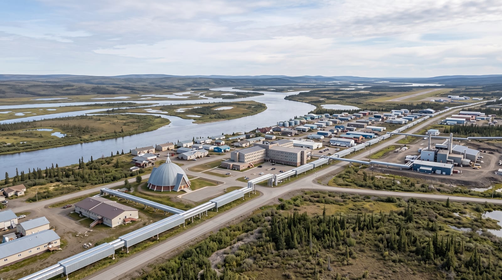
AI illustration
Inuvik was built from 1955 as a planned replacement for flood-prone Aklavik, and everything about it answers permafrost: buildings stand on piles driven into frozen ground so their heat cannot thaw it, and the water, sewer and heating lines run above ground through insulated aluminium boxes called utilidors that snake between buildings, because burying them is impossible. Our Lady of Victory church, built by a missionary and volunteers in the 1950s, is a dome shaped like an igloo. The sun stays up continuously for about fifty-six days from late May, and stays down for about thirty days in the winter.
History
Inuvik was conceived in 1953 as a new administrative centre to replace Aklavik on the west of the Mackenzie Delta, which was prone to flooding and had no room to grow; first called New Aklavik, it was renamed Inuvik, Inuvialuktun for living place, in 1958. The school opened in 1959 and the hospital, government offices and staff houses in 1960, when Inuvialuit, Gwich'in and Métis people began to live in the town; it became a village in 1967 and a town in 1979, the year the Dempster Highway joined it to Canada's road network, and the year-round highway to Tuktoyaktuk opened in November 2017 (Wikipedia, Inuvik).
The main sights
- The utilidors - above-ground insulated service lines running through town.
- The igloo church - a domed 1950s church built by volunteers.
- The buildings on piles - structures raised off the permafrost.
- The midnight sun - continuous daylight for about fifty-six days.
When to go
June to September for the midnight sun and road access; winter brings the aurora and the ice road to Tuktoyaktuk was replaced by an all-season highway in 2017. Winter darkness runs about thirty days.
Good to know
Everything is expensive, since supplies come up the Dempster or by air. The igloo church has limited visiting hours. Winter temperatures reach minus forty with darkness.
Nearby
Tuktoyaktuk lies north on the highway; the Dempster runs south.
Key facts
Source: Wikidata, item Q338686, read on 18 October 2026.
What to pack for Inuvik
Chosen from what this place is for. Tap a kit for the full checklist.
- Spare batteries + cards - Cold and long shoots drain power; never run out at the good light. Find on Amazon
- Warm base layers - Merino or synthetic against the skin - never cotton, which chills when damp. Find on Amazon
- Comfortable walking shoes - Sightseeing means kilometres of pavement and cobbles daily. Find on Amazon
- A compact tripod - Essential for night skies, aurora, waterfalls and low light. Find on Amazon
Some links on this page are Amazon affiliate links - if you buy through them we may earn a small commission at no extra cost to you.
All packing kitsPlan your trip
Where to start if Inuvik is going on the list.
Booking links on this page are affiliate links - if you book through them we may earn a small commission at no extra cost to you. It never changes what we write about a place.
Opening times, ticket prices and seasonal closures change - check the official source before you go: official site.