Silvretta High Alpine Road
A toll pass road from the Montafon to the Paznaun over 2,032 metres, past a reservoir under the Piz Buin.
Updated 21 October 2026
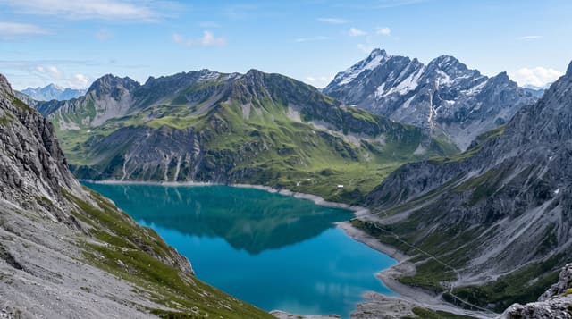
The Silvretta-Hochalpenstrasse crosses the Bielerhöhe at two thousand and thirty-two metres between the Montafon in Vorarlberg and the Paznaun in Tyrol, about twenty-two kilometres with thirty-four hairpins, built in the 1950s alongside the hydroelectric scheme and tolled. At the top is the Silvretta reservoir, held by dams begun in 1938 and first filled to the top in 1951, with the Piz Buin and the glaciated peaks of the Silvretta group behind it - the same mountains that gave a well-known sunscreen its name, after the chemist Franz Greiter was sunburned climbing the Piz Buin in 1938. There is a path round the reservoir, boats in summer, huts, and routes onto the ice. The road closes with the first heavy snow and reopens when it is cleared, typically late spring.
Highlights
- A pass at 2,032 metres - thirty-four hairpins between Vorarlberg and Tyrol.
- The Silvretta reservoir - the dams begun in 1938, under the Piz Buin and its glaciers.
- Glaciated peaks - the Silvretta group, and the sunburn story that named a sunscreen.
- A lake circuit path - the walk round the reservoir at the top.
When to go
June to September; the road is closed by snow the rest of the year. Half a day.
Practical notes
Tolled and shut for much of the year. Weather at the top turns fast and is often cold and wet. Motorcycle and cyclist traffic is heavy at weekends. The glaciers have retreated substantially.
Nearby
Galtür and Ischgl are east; the Montafon and Bludenz are west.
Key facts
Source: Wikidata, item Q2286875, read on 18 October 2026.
What to pack for Silvretta High Alpine Road
Chosen from what this place is for. Tap a kit for the full checklist.
- Padded shorts - The one thing that makes a full day in the saddle bearable. Find on Amazon
- Warm base layers - Merino or synthetic against the skin - never cotton, which chills when damp. Find on Amazon
- Comfortable walking shoes - Sightseeing means kilometres of pavement and cobbles daily. Find on Amazon
- Shelter suited to the place - Tent, tarp or hut booking - match it to the terrain and rules. Find on Amazon
Some links on this page are Amazon affiliate links - if you buy through them we may earn a small commission at no extra cost to you.
All packing kitsPlan your trip
Where to start if Silvretta High Alpine Road is going on the list.
Booking links on this page are affiliate links - if you book through them we may earn a small commission at no extra cost to you. It never changes what we write about a place.
Opening times, ticket prices and seasonal closures change - check the official source before you go: official site.