Nyika Plateau National Park
The Zambian side of a high montane grassland plateau on the Malawi border.
Updated 16 October 2026
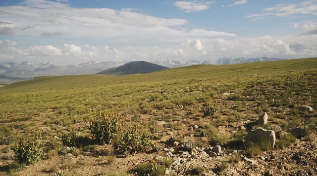
Nyika is a high rolling grassland plateau straddling the Zambia and Malawi border, and the Zambian portion is the smaller share: open downland at around two thousand metres with pockets of evergreen forest in the folds, cool enough for frost at night and covered in wild flowers and orchids in the rains. Roan antelope, eland and reedbuck graze it. The Zambian side has almost no infrastructure and most people reach the plateau from Malawi.
Background
The park takes the western edge of the Nyika Plateau, one of the highest parts of Zambia, and is much smaller than the Malawian park next to it. The north-south plateau road divides the two and is the only road in; it begins and ends in Malawi, entered via the M14 at Chisenga or Katumbi, the nearest entry points. The Nyika Guesthouse, dating from around 1946 and standing on the Zambian side, was once the only place to stay in either park, and it closed in 1998. With two smaller highland areas to the north, the plateau is Zambia's only example of the Southern Rift montane forest-grassland mosaic ecoregion. Many kinds of wildflowers bloom between September and April.
Source: Wikipedia, "Nyika National Park, Zambia"
What's there
- The montane grassland - open downland at around two thousand metres.
- The forest pockets - evergreen patches in the folds of the hills.
- The orchids - the flowering that follows the rains across the plateau.
- The antelope - roan, eland and reedbuck grazing the open ground.
When to go
May to October is dry, cold at night and best for driving. The rains bring flowers but close tracks. Frost is common in June and July.
Good to know
The Zambian side has essentially no facilities and access is very rough. Most visitors come from the Malawi side instead. Nights are genuinely cold and camping needs proper gear.
Nearby
Luambe is west, and Mutinondo is southwest.
Key facts
Source: Wikidata, item Q5965566, read on 18 October 2026.
What to pack for Nyika Plateau National Park
Chosen from what this place is for. Tap a kit for the full checklist.
- Broken-in walking shoes or boots - Grip and ankle support matter more than looks; never hike in brand-new boots. Find on Amazon
- Binoculars - The single best wildlife tool - even a compact pair transforms a sighting. Find on Amazon
- Shelter suited to the place - Tent, tarp or hut booking - match it to the terrain and rules. Find on Amazon
- Layers + a waterproof shell - Mountain weather turns fast; a packable rain jacket saves the day. Find on Amazon
Some links on this page are Amazon affiliate links - if you buy through them we may earn a small commission at no extra cost to you.
All packing kitsPlan your trip
Where to start if Nyika Plateau National Park is going on the list.
Booking links on this page are affiliate links - if you book through them we may earn a small commission at no extra cost to you. It never changes what we write about a place.
Opening times, ticket prices and seasonal closures change - check the official source before you go: official site.