Kızkumu
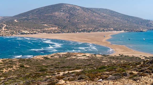
A submerged reddish sandbar at Orhaniye that lets you walk six hundred metres out into the bay in knee-deep water.
Updated 25 August 2026
Kızkumu - maiden's sand - is a natural bar of coarse reddish sand and gravel running out from the shore at Orhaniye across most of the width of the bay, sitting a foot or two below the surface. The effect is the attraction: people walk out along it for several hundred metres with water to the knee or thigh and deep blue on either side, which from the shore looks like walking on the sea. The legend attached explains it as a princess fleeing pirates who carried sand in her skirts to build a path, and drowned when it ran out - hence the name. Geologically it is a spit of eroded reddish rock deposited by currents. The bay behind is a sheltered yacht anchorage with restaurants and small hotels along the shore. Staying on the bar matters: step off the edge and it drops away sharply, and the bar itself is eroding, so walking it in single file rather than trampling the edges is asked of visitors.
What you'll find
- The submerged bar - the walk out into the middle of the bay.
- The red sand - the distinctive coarse reddish grains.
- The sheltered bay - yachts anchored in Orhaniye's inlet.
- The pine shores - forested slopes around the water.
When to go
May to June and September to October. Calm days make the bar easiest to see and walk; wind and chop obscure it.
What to expect
The drop-off either side of the bar is sudden and deep - keep to it and watch children closely. The bar is eroding and visitors are asked to walk single file. It is a pebble-and-gravel shore, not a sandy beach.
Nearby
Bozburun and Selimiye are further down the peninsula; Marmaris is about 25 km north.
Key facts
Source: Wikidata, item Q131902262, read on 18 October 2026.
What to pack for Kızkumu
Chosen from what this place is for. Tap a kit for the full checklist.
- Broken-in walking shoes or boots - Grip and ankle support matter more than looks; never hike in brand-new boots. Find on Amazon
- Layers + a waterproof shell - Mountain weather turns fast; a packable rain jacket saves the day. Find on Amazon
- Daypack with rain cover - 20-30 litres holds water, snacks, layers and a first-aid kit. Find on Amazon
- Offline maps + a power bank - Download the trail before you lose signal; carry backup charge. Find on Amazon
Some links on this page are Amazon affiliate links - if you buy through them we may earn a small commission at no extra cost to you.
All packing kitsPlan your trip
Where to start if Kızkumu is going on the list.
Booking links on this page are affiliate links - if you book through them we may earn a small commission at no extra cost to you. It never changes what we write about a place.
Opening times, ticket prices and seasonal closures change - check the official source before you go: official site.