Douiret
An abandoned Berber village on a steep hillside south of Tataouine, with a white mosque and cave houses.
Updated 16 October 2026
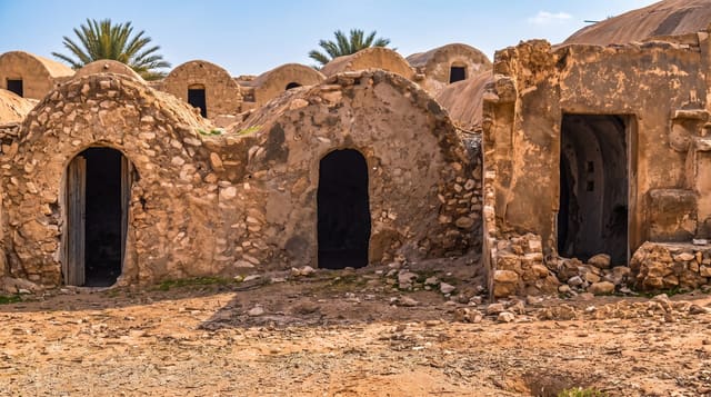
Douiret is built up a steep hillside southwest of Tataouine, houses and storage cells cut into the soft rock in terraces below a ruined ksar on the summit, and it was almost entirely abandoned in the twentieth century when the population moved to a new village on the plain. A whitewashed mosque with a square minaret stands out against the ochre rock. A few restored houses now take guests, and the old village is walked through rather than lived in.
Background
The village is thought to trace its origins to a founding father, Ghazi Ben Douaieb Bou Kenana, who arrived in the area more than 600 years ago, possibly from the Tafilalet region of Morocco. In 1850 it had around 3500 inhabitants. Through the 20th century many people left, mostly for Tunis, and the last families moved to the new village of Douiret at the foot of the mountain. Troglodyte houses dug into the mountain follow the cliff in a winding line below the citadel. A path of about 3 km passes the abandoned dwellings, with the white mosque about halfway along, which people call Jamaa ennakhla, the palm tree mosque. Douiret lies 22 km southwest of Tataouine.
Source: Wikipedia, "Douiret"
What to look for
- The terraced village - houses and cells cut into the hillside in tiers.
- The white mosque - the whitewashed mosque standing against the ochre rock.
- The hilltop ksar - the ruined fortified granary on the summit.
- The cave houses - dwellings dug into the soft rock of the slope.
When to go
October to April is comfortable; summer is extreme. Late afternoon gives the best light. The climb is steep and exposed.
Practical notes
The village is largely ruined and the buildings are unsafe to enter. There is no shade and the climb is hard work. Facilities are limited to a couple of restored guesthouses.
Nearby
Chenini is north, and Tataouine is northeast.
Key facts
Source: Wikidata, item Q311889, read on 18 October 2026.
What to pack for Douiret
Chosen from what this place is for. Tap a kit for the full checklist.
- Head torch + spare batteries - Hands-free light is essential; caves are truly dark. Find on Amazon
- Comfortable walking shoes - Sightseeing means kilometres of pavement and cobbles daily. Find on Amazon
- Modest clothing - Shoulders and knees covered - the single most common requirement. Find on Amazon
- Grippy closed shoes - Cave floors are wet, muddy and slick with formations. Find on Amazon
Some links on this page are Amazon affiliate links - if you buy through them we may earn a small commission at no extra cost to you.
All packing kitsPlan your trip
Where to start if Douiret is going on the list.
Booking links on this page are affiliate links - if you book through them we may earn a small commission at no extra cost to you. It never changes what we write about a place.
Opening times, ticket prices and seasonal closures change - check the official source before you go: official site.