Tun Sakaran Marine Park
A ring of volcanic islands round a lagoon, with a hard climb up Bohey Dulang for the view down into it.
Updated 20 October 2026
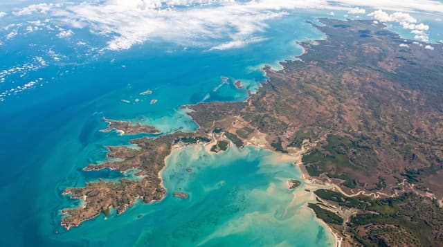
Tun Sakaran, gazetted in 2004, covers about three hundred and fifty square kilometres off Semporna around a group of islands - Bodgaya, Boheydulang, Sabangkat, Selakan, Maiga, Sibuan and Mantabuan - which are the eroded rim of an old volcanic caldera, so the islands curve around a shared shallow lagoon of exceptional clarity. The standard trip is a steep climb of about forty-five minutes up Bohey Dulang to a ridge viewpoint looking straight down into the lagoon with the islands curving away, which is the photograph everyone has seen of Sabah, followed by snorkelling. The park is inhabited: Bajau Laut communities live in and around it, some stateless, and the tension between conservation rules, fishing rights and statelessness is real and unresolved. Fish bombing damaged reefs here badly and enforcement has improved but not eliminated it.
History
Bodgaya was first gazetted as a forest reserve in 1933 and Boheydulang as a bird sanctuary, a state park was first proposed in 1977, and in 1998 the Semporna Islands Project, joining the Marine Conservation Society, Sabah Parks, WWF Malaysia and Nature Link, took the plans forward (Wikipedia, Tun Sakaran Marine Park).
Highlights
- A drowned caldera - islands curving as the rim around a shared shallow lagoon.
- The Bohey Dulang climb - forty-five steep minutes to the ridge above the lagoon.
- Bajau Laut communities - living in the park, some without citizenship.
- Reef damage and recovery - fish bombing legacy with enforcement now in place.
When to go
April to December. A day.
Practical notes
The Bohey Dulang climb is steep, hot and slippery. Permits are required and go through licensed operators.
Nearby
Semporna is the departure point; Mabul and Sipadan are south-east.
Key facts
Source: Wikidata, item Q7852775, read on 18 October 2026.
What to pack for Tun Sakaran Marine Park
Chosen from what this place is for. Tap a kit for the full checklist.
- Broken-in walking shoes or boots - Grip and ankle support matter more than looks; never hike in brand-new boots. Find on Amazon
- Travel rod + reel - A packable multi-piece rod fits in a case and covers most holiday fishing. Find on Amazon
- Reef-safe sunscreen - High SPF that will not bleach the coral you are swimming over. Find on Amazon
- Your own mask + snorkel - A well-fitting mask is the single biggest comfort upgrade underwater. Find on Amazon
Some links on this page are Amazon affiliate links - if you buy through them we may earn a small commission at no extra cost to you.
All packing kitsPlan your trip
Where to start if Tun Sakaran Marine Park is going on the list.
Booking links on this page are affiliate links - if you book through them we may earn a small commission at no extra cost to you. It never changes what we write about a place.
Opening times, ticket prices and seasonal closures change - check the official source before you go: official site.