Kangerlussuaq
An inland settlement at what was Greenland's main international airport until 2024, with road access to the ice cap.
Updated 19 October 2026
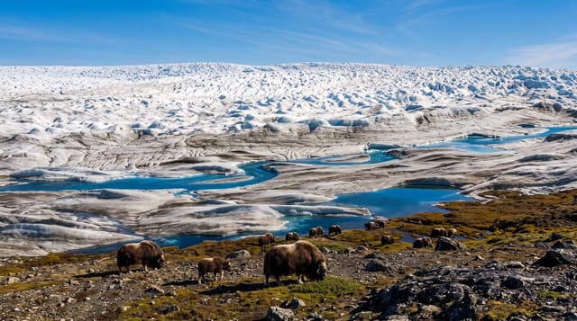
Kangerlussuaq sits at the head of a long fjord inland from the west coast, a former American air base that was Greenland's main international airport, because its position far from the coast gives it more reliable weather than anywhere else, until the rebuilt Nuuk Airport opened in November 2024 and took over as the hub. The population fell from 564 to 399 between 2024 and 2025. A gravel road of about thirty kilometres runs from the settlement to the edge of the inland ice, the only road in Greenland that reaches the ice cap.
History
The settlement and airport began as a U.S. air base founded on 7 October 1941 at the east end of the fjord under Colonel Bernt Balchen, and the base became a Greenlandic settlement in 1992, when the last U.S. Air Force personnel left. From the mid-1950s transatlantic civilian flights stopped here to refuel, and in 1956 Scandinavian Airlines flew a polar route from Copenhagen via Søndre Strømfjord to Winnipeg and Los Angeles, building a hotel that is still in use; the airport remained Greenland's main transport hub until the rebuilt Nuuk Airport opened in November 2024 (Wikipedia, Kangerlussuaq).
The landscape
- The ice cap road - about thirty kilometres of gravel to the edge of the inland ice.
- The airport - the former air base that was the country's hub until Nuuk's new runway opened in 2024.
- The musk oxen - the herds on the tundra around the settlement.
- The stable weather - the inland position that keeps the strip open.
When to go
June to September for hiking and ice cap trips. Winter for aurora, with very cold clear nights. The airport operates year round.
Before you go
The settlement itself is an airport town with little charm and limited facilities. Ice cap tours are expensive for what is a short drive. It lost its role as the main airport to Nuuk in November 2024, so check which flights still come here before building a trip around it.
Nearby
Sisimiut is west at the end of the Arctic Circle Trail, and Maniitsoq is south.
Key facts
Source: Wikidata, item Q1007098, read on 18 October 2026.
What to pack for Kangerlussuaq
Chosen from what this place is for. Tap a kit for the full checklist.
- Broken-in walking shoes or boots - Grip and ankle support matter more than looks; never hike in brand-new boots. Find on Amazon
- Spare batteries + cards - Cold and long shoots drain power; never run out at the good light. Find on Amazon
- Warm base layers - Merino or synthetic against the skin - never cotton, which chills when damp. Find on Amazon
- Layers + a waterproof shell - Mountain weather turns fast; a packable rain jacket saves the day. Find on Amazon
Some links on this page are Amazon affiliate links - if you buy through them we may earn a small commission at no extra cost to you.
All packing kitsPlan your trip
Where to start if Kangerlussuaq is going on the list.
Booking links on this page are affiliate links - if you book through them we may earn a small commission at no extra cost to you. It never changes what we write about a place.
Opening times, ticket prices and seasonal closures change - check the official source before you go: official site.