Utsjoki and the Teno River
The northernmost municipality in Finland, on a salmon river forming the border with Norway.
Updated 31 August 2026
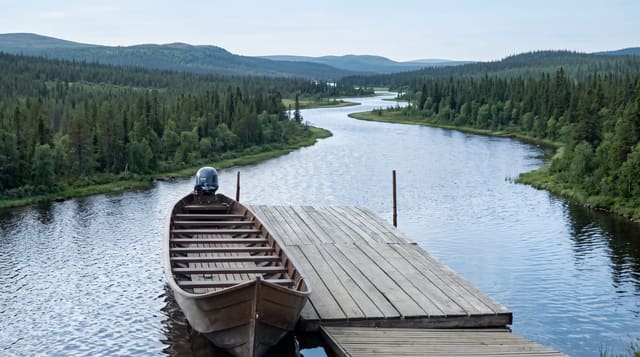
Utsjoki is the northernmost municipality in Finland, the only one with a Sami majority, and it lies along the Teno, called Deatnu in North Sami, a large river that forms the border with Norway and has been one of the most productive Atlantic salmon rivers in Europe. Fishing on it is regulated jointly by the two countries and has been restricted heavily in recent years as salmon numbers fell, with closures in some seasons. The landscape is open fell and birch forest, with the Kevo canyon nearby, a deep gorge with a long trekking route through it. Utsjoki village has a church, and a group of church huts stands at Mantojarvi where people once stayed for services.
What's there
- The Teno river - the border salmon river running north-east.
- Sami-majority Utsjoki - the northernmost municipality in the country.
- The church huts at Mantojarvi - shelters used by people attending services.
- Open fell and birch forest - the landscape of the far north.
When to go
July to September for walking and the light, and March to April for snow and returning daylight. Two days or more. Salmon fishing rules change year to year and closures are common; check current regulations.
Things to know
Salmon fishing has been closed or heavily restricted in recent seasons and cannot be assumed. It is a long drive from anywhere and services are limited. Mosquitoes in July are severe. This is a Sami area and local customs and land use deserve respect.
Nearby
Kevo canyon is south-west; the Norwegian border runs along the river.
What to pack for Utsjoki and the Teno River
Chosen from what this place is for. Tap a kit for the full checklist.
- Broken-in walking shoes or boots - Grip and ankle support matter more than looks; never hike in brand-new boots. Find on Amazon
- Travel rod + reel - A packable multi-piece rod fits in a case and covers most holiday fishing. Find on Amazon
- Warm base layers - Merino or synthetic against the skin - never cotton, which chills when damp. Find on Amazon
- Shelter suited to the place - Tent, tarp or hut booking - match it to the terrain and rules. Find on Amazon
Some links on this page are Amazon affiliate links - if you buy through them we may earn a small commission at no extra cost to you.
All packing kitsPlan your trip
Where to start if Utsjoki and the Teno River is going on the list.
Booking links on this page are affiliate links - if you book through them we may earn a small commission at no extra cost to you. It never changes what we write about a place.
Opening times, ticket prices and seasonal closures change - check the official source before you go: official site.