Bacalar Chico National Park
A remote reef and mangrove reserve at the northern tip of Ambergris Caye, part of the Belize Barrier Reef World Heritage site.
Updated 18 October 2026
UNESCO World Heritage
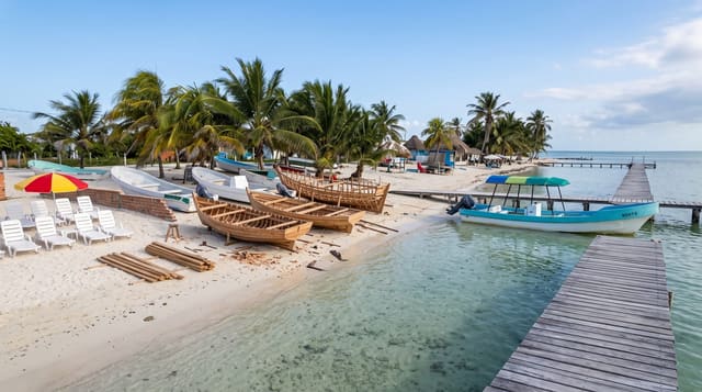
Bacalar Chico covers the northern end of Ambergris Caye and the water around it, and it is one of the seven protected areas that make up the Belize Barrier Reef Reserve System, inscribed as World Heritage in 1996. The name comes from a channel the Maya cut through the caye to shorten the trading route, which now forms the border with Mexico. Littoral forest, mangrove, seagrass and reef sit together here, and there is almost nobody about.
History
The reserve grew out of the early 1990s, when the Broadhead Group planned a community for retirees on northern Ambergris Caye and an environmental impact assessment by the Belize Center for Environmental Studies found unusually high biodiversity for a barrier island. Fishermen in San Pedro and the mainland village of Sarteneja were worried about the depletion of marine resources, and, encouraged by the success of the Hol Chan Marine Reserve, the San Pedro NGO Greenreef drew up a management plan in 1995; a year later Bacalar Chico was officially recognised as a national park and marine reserve, though for the next three years it was protected in name only. Since 2004 the Government of Belize has been responsible for it, providing US$100,000 a year for operations and the salaries of the park's four rangers (Wikipedia, Bacalar Chico National Park and Marine Reserve).
Highlights
- The Maya-cut channel - the canal dug through the caye, now the Mexican border.
- The reef - part of the World Heritage barrier system, with almost no boat traffic.
- The littoral forest - dry coastal forest on the caye's northern end.
- The visitor centre - a small station at San Juan with displays on the reserve.
When to go
December to April is the dry season with the calmest water. The boat run from San Pedro takes ninety minutes each way and is cancelled in rough conditions. Mosquitoes on land are severe.
Practical notes
Getting there means a long boat charter and most people combine it with a full-day trip. Facilities are minimal and there is no accommodation. Sandflies and mosquitoes on the caye are punishing.
Nearby
San Pedro is south down the caye, and Hol Chan is beyond it.
Key facts
Source: Wikidata, item Q4838578, read on 18 October 2026.
What to pack for Bacalar Chico National Park
Chosen from what this place is for. Tap a kit for the full checklist.
- Broken-in walking shoes or boots - Grip and ankle support matter more than looks; never hike in brand-new boots. Find on Amazon
- Binoculars - The single best wildlife tool - even a compact pair transforms a sighting. Find on Amazon
- Layers + a waterproof shell - Mountain weather turns fast; a packable rain jacket saves the day. Find on Amazon
- A zoom camera or long lens - Animals rarely come close; reach beats megapixels. Find on Amazon
Some links on this page are Amazon affiliate links - if you buy through them we may earn a small commission at no extra cost to you.
All packing kitsPlan your trip
Where to start if Bacalar Chico National Park is going on the list.
Booking links on this page are affiliate links - if you book through them we may earn a small commission at no extra cost to you. It never changes what we write about a place.
Opening times, ticket prices and seasonal closures change - check the official source before you go: official site.